Agriculture Crop Monitoring
Revolutionize farming operations with autonomous robots designed to scan, analyze, and report on crop health in real-time. By leveraging computer vision and AI, this application provides actionable insights to optimize yield, reduce resource waste, and detect early signs of disease.
Why Automate Agriculture Crop Monitoring?
Maximize Crop Yields
Identify growth patterns and nutrient deficiencies early to take corrective actions that significantly boost harvest volume.
Early Disease Detection
High-resolution multispectral cameras detect fungal infections and pests before they become visible to the human eye.
Precision Resource Usage
Apply water, fertilizer, and pesticides only where needed, reducing operational costs and environmental impact.
24/7 Autonomous Operation
Robots operate independently of labor shortages or daylight, ensuring continuous monitoring of large acreages.
Scalable Infrastructure
Easily deploy fleets of monitoring robots that communicate and coordinate to cover expanding farmland efficiently.
Data-Driven Forecasting
Accumulate historical data to improve predictive models, allowing for better financial planning and risk management.
How The Technology Works
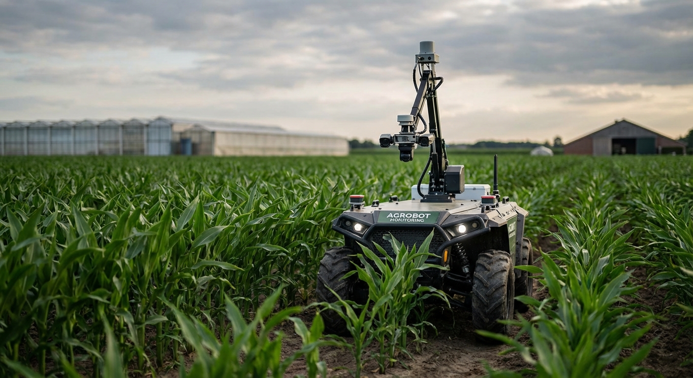
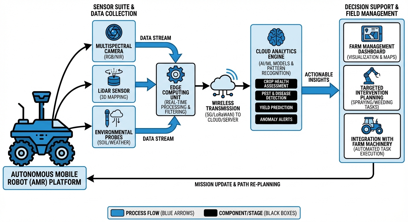
The autonomous robot utilizes Real-Time Kinematic (RTK) GPS and LIDAR sensors to navigate rows of crops with centimeter-level precision, avoiding obstacles and maintaining consistent pathing without damaging plants.
Equipped with multispectral and RGB cameras, the robot captures high-resolution imagery of every plant. Onboard edge computing processes these images instantly using machine learning models trained to recognize specific crop diseases, hydration levels, and growth stages.
Data is synthesized into a "digital twin" of the field. Farmers can access a dashboard to view heat maps of plant health, receive alerts for specific problem areas, and generate prescription maps for automated sprayers or irrigation systems.
Where It's Used
Vineyards & Viticulture
Precision monitoring of grape vines to determine optimal harvest time (veraison) and manage canopy vigor for premium wine production.
Broad-Acre Farming
Large-scale monitoring of wheat, corn, and soy to generate nitrogen application maps and detect invasive weed species across thousands of acres.
Orchards & Fruit Production
Automated fruit counting for yield estimation and monitoring tree health to prevent spread of blight in apple, orange, and almond orchards.
Greenhouses & Vertical Farms
Indoor navigation to monitor hydroponic systems, ensuring precise climate control and detecting mold in high-humidity environments.
What You Need
| Category | Requirements |
|---|---|
| Sensors & Payload | Multispectral Camera (NDVI support), High-Res RGB Camera, RTK-GPS Module, LIDAR (for obstacle avoidance). |
| Robot Capabilities | All-terrain suspension, 4+ hour battery life, IP65/IP67 weather rating, ROS2 navigation stack. |
| Compute & Software | Onboard Edge GPU (e.g., Jetson Orin), Computer Vision Inference Engine, Fleet Management API. |
| Connectivity | 4G/5G Cellular Module or Long-Range LoRaWAN for telemetry, Local Wi-Fi for bulk data offload. |
Frequently Asked Questions
How does the robot distinguish between crops and weeds?
The robot uses deep learning models trained on thousands of labeled images. It analyzes leaf shape, texture, and color spectrum to classify plants as either crops or weeds with high accuracy, typically above 95%.
Can the robot operate in rain or muddy conditions?
Yes, the hardware is rated IP65 or higher, making it water-resistant. However, extremely muddy conditions may affect traction. The system includes traction control and torque vectoring to handle typical agricultural terrain.
What is the battery life and charging time?
Standard configurations run for 4-6 hours on a single charge. The system supports autonomous docking stations for self-charging, allowing for continuous 24/7 operation cycles with minimal downtime.
Does it require an internet connection in the field?
No. The robot processes data locally (Edge Computing). It only requires connectivity to upload final reports or receive new pathing instructions, which can be done when it returns to the base station.
How precise is the location data?
With RTK-GPS integration, the robot achieves centimeter-level accuracy (approx. 1-2cm). This allows it to revisit specific individual plants over time to track their specific growth progression.
Can it work at night?
Yes. The robot is equipped with LIDAR for navigation in total darkness and active LED lighting systems to facilitate camera operation during night patrols.
Is the data compatible with other farm management software?
Yes, the data is exported in standard formats (GeoJSON, Shapefiles) and offers API integrations with major Farm Management Information Systems (FMIS) like John Deere Operations Center and Climate FieldView.
What happens if the robot gets stuck?
The robot will attempt autonomous recovery maneuvers. If unsuccessful, it triggers a remote alert to the operator with its precise coordinates and a camera feed of the obstruction.
Can it navigate on slopes?
The robot is designed with a low center of gravity and can safely navigate slopes up to 20 degrees. For steeper terrain, specialized chassis configurations are available.
Is data privacy guaranteed?
Absolutely. All collected data belongs to the farm owner. We utilize end-to-end encryption for transmission and storage, ensuring your crop data remains confidential and secure.